Category: Drawings

  • What is a floor plan?

    What is a floor plan?

    A floor plan is a detailed drawing that provides a visual representation of the features on a specific floor of a property. In the context of a measured building survey, a floor plan includes all fixed features, such as room dimensions, windows, doors, and ceiling beams, as well as height information (Source: Authentic Property Survey). This type of floor plan is essential for planning permission and construction drawings, as it provides accurate measurements and layouts (Source: The RICS). The floor plan is a crucial component of a measured building survey, which involves measuring the property’s dimensions, layout, and features using specialized equipment (Source: Ratcliffe Property Surveyors).

    Unlike estate agent floor plans, which are typically produced for marketing purposes and lack accuracy, measured building survey floor plans are designed to meet specific needs and requirements (Source: The National House-Building Council). These plans are created using specialized equipment, such as FARO 3D scanners or Leica Total Stations, which allow surveyors to capture precise measurements and layouts (Source: FARO Systems). As a result, measured building survey floor plans are more accurate and comprehensive than those produced by estate agents

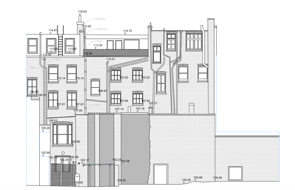
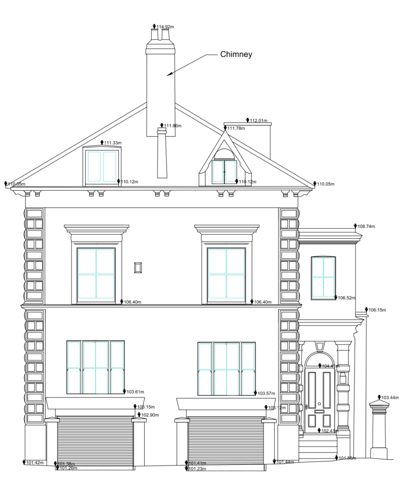
    Figurative 1: A screenshot of a floor plan produced from a measured building survey. This image shows the level of detail and accuracy that is achievable using specialized equipment and survey techniques. Note the precise measurements and layouts, as well as the inclusion of features such as windows, doors, and ceiling beams (Source: Authentic Property Survey). To better understand the potential cost and time implications of measured building surveys, consider the following:

    Measured building surveys using specialist equipment can be more expensive, typically ranging from £250 to £1000 per week to hire (Source: Ratcliffe Property Surveyors). Additionally, these surveys can take longer to complete than estate agent floor plans, as the equipment and techniques used require more time and expertise. However, the resulting floor plans are more accurate and comprehensive, making them an indispensable tool for planning permission and construction drawings

    To illustrate the level of accuracy and detail that can be achieved using measured building surveys, consider the use of equipment such as FARO 3D scanners. These scanners can capture precise measurements and layouts, and are capable of producing high-quality floor plans in a relatively short amount of time (Source: FARO Systems). Overall, measured building survey floor plans offer a level of accuracy and detail that is unmatched by estate agent floor plans, making them an essential component of planning permission and construction drawings

    References

    • How to get the best Prices for a Measured Building Survey or Topographical Survey?

      When preparing for a measured building survey, it is essential to work closely with your architect to ensure that the scope of the survey accurately captures the necessary details for both your planning application and construction phase. In fact, according to the Building Conservation Society, some architectural features such as sockets, lights, and internal glazing may not be standard measurements in a survey. Therefore, it is crucial to review the scope of work with your architect to avoid any misunderstandings or inaccuracies.

      To confirm that you are providing the correct information to the surveyors, you can also ask your architect to review the scope that you will produce. This simple step can help prevent any potential errors or oversights, ensuring that your surveyor has all the necessary details to complete the task accurately. A well-drafted scope is also vital for obtaining a fair and accurate price for your construction project.

      To summarize, the key to a successful measured building survey lies in ensuring that you provide the surveyor with as much and accurate information as possible. By collaborating closely with your architect and reviewing the scope of work, you can avoid any potential pitfalls and achieve a fair and accurate price for your construction project. Our Scope Sheet for Surveying can serve as a valuable resource to help you get started on the right foot.

      References

      • What is a Plan, is this a drawing?

        A plan is a drawing; in the context of measured building survey and topographical surveys, it represents the features on your property on a PDF or DWG drawing. These are used for your planning application and for your architect to produce your construction (proposed) drawings. According to the UK Government’s Planning Portal, plans are a crucial aspect of the planning application process, as they provide essential information about the property’s layout and boundaries (Source: UK Government’s Planning Portal). There are several types of plans, each serving a specific purpose in the planning process.

        • Floor Plans
        • Section Plans
        • Roof Plans
        • Loft Plans
        • Elevation Plans
        • Topographical Plans (or also called Land Survey Plans)
        • Ceiling Plans

        It’s essential to note that plans are not the same as site plans. A site plan is a drawing/illustration that shows your property in context to other properties. It is based on an Ordnance map and can be purchased online, with prices ranging from £8-10, depending on the scale (Source: BuyAPlan.co.uk). You need one for all planning applications. A site plan provides a visual representation of the property’s location and boundaries, which is vital for the planning process.

        Here are some examples of the plans mentioned above:

        floor plans are a crucial aspect of the planning process, providing a detailed representation of the property’s layout and boundaries. They are typically created using CAD software and are used to produce construction drawings (Source: Architects’ Journal). Floor plans can be customized to meet specific requirements, making them an essential tool for architects and developers.

        Section plans provide a detailed representation of a specific section of the property, such as a wall or a room. They are useful for highlighting architectural features and can be used to create 3D models of the property (Source: ArchDaily). Section plans can be created using various software tools, including CAD and BIM.

        Roof plans are a critical component of the planning process, as they provide essential information about the property’s roof structure and layout. They are typically created using CAD software and are used to produce construction drawings (Source: Building Design). Roof plans can be customized to meet specific requirements, making them an essential tool for architects and developers.

        loft plans are a type of floor plan that focuses on the property’s loft space. They are useful for highlighting architectural features and can be used to create 3D models of the property (Source: The Guardian). Loft plans can be created using various software tools, including CAD and BIM.

        Elevation plans provide a detailed representation of the property’s exterior, including walls, windows, and doors. They are typically created using CAD software and are used to produce construction drawings (Source: The Times). Elevation plans can be customized to meet specific requirements, making them an essential tool for architects and developers.

        Topographical plans, also known as land survey plans, provide a detailed representation of the property’s boundaries and layout. They are typically created using CAD software and are used to produce construction drawings (Source: The Telegraph). Topographical plans can be customized to meet specific requirements, making them an essential tool for architects and developers.

        ceiling plans provide a detailed representation of the property’s ceiling layout and features. They are typically created using CAD software and are used to produce construction drawings (Source: Building Design). Ceiling plans can be customized to meet specific requirements, making them an essential tool for architects and developers.

        Floor Plan Example 3 serves as a crucial step in the architectural design process. It allows designers to visualize the layout and proportions of a space, making it easier to identify potential issues and optimize the design.

        Section Plan Example 1 provides a detailed view of a specific section of the building, allowing designers to examine the relationships between different elements and components.

        Section Plan Example 2 showcases a more detailed and complex section of the building, highlighting the relationships between different components and systems.

        Topographical Plan Example provides a visual representation of the building’s site and its relationship to the surrounding environment.

        Loft Plan Example provides a detailed view of the building’s interior spaces, highlighting the relationships between different components and systems.

        Elevation Plan Example showcases a detailed view of the building’s exterior, highlighting the relationships between different components and systems.

        References

        • What is an Elevation Plan?

          An elevation is a plan that shows the front, side, and rear facade (or lead of the building). This includes window/door positions, different surfaces; and, height of the building.

          • Window/door positions,
          • different surfaces; and,
          • height of the building.

          Elevations are usually required whenever your planning proposal requires external alterations of the property.
          Elevations can form part of a street scene drawing. A street scene is a collection of several properties’ elevations as viewed from the street. This needs to detail the different materials, window position, heights and any other features…

          That can demonstrate the style and look of other buildings on your property. This is necessary for planning applications where you are planning on changing the outlook of your property.

          Examples

          Here are some examples of elevations:

          Example of an Elevation plan
          Example of an Elevation plan

          Point cloud of an elevation
          Point cloud of an elevation
          Point cloud of an elevation
          Point cloud of an elevation

        Exit mobile version