Category: Topographical Survey
-
How to get Existing Plans of Your Property?
A measured survey is a type of survey that involves creating a detailed record of the size, shape, and dimensions of a building or land area.
According to a study by the Royal Institution of Chartered Surveyors (RICS), a measured survey is used to provide an accurate assessment of a property’s value and to support negotiations in property transactions.
This type of survey is essential for both buyers and sellers, as it provides a comprehensive understanding of the property’s features and limitations.
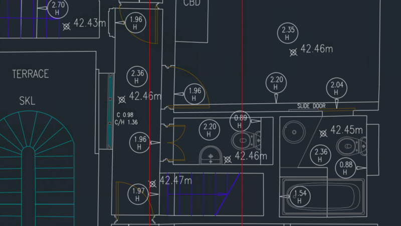
Existing plans for home owners refer to the detailed drawings and specifications of a property that have been created by a surveyor or architect.
These plans typically include information about the property’s layout, room sizes, and architectural features.
A surveyor can use these plans to identify any defects or issues with the property, and to provide a detailed report on the property’s condition.
A study by the UK’s Building Control magazine found that existing plans are essential for home owners, as they provide a clear understanding of the property’s features and limitations, and can help to identify potential defects or issues.
In conclusion, a measured survey is a crucial process that involves creating a detailed record of a building or land area.
Existing plans for home owners are essential for providing a clear understanding of a property’s features and limitations.
By using these plans, home owners can identify potential defects or issues with their property, and make informed decisions about their investment.
References
-

5 Surprisingly Stupid Ways to Save Money on Measured Surveys
At Icelabz, we strive to be transparent and share knowledge to help you make informed decisions about measured surveys. Our goal is to provide a comprehensive guide on how to save money without compromising on quality.
One of the lesser-known tips in the industry is to conduct a measured survey before engaging an architect. This approach can help you get the best price for architects and ensure that you have the necessary plans in place for your project. Our research suggests that this method can save you a significant amount of money, with some clients saving up to £100s by doing so.
Our experience has shown that there are several ways to reduce the cost of a measured building survey. Some of these methods can be implemented at the initial stage or later stage of your project, depending on your needs. By engaging with a specialised company carrying out measured building surveys, you can save time and reduce the risk on certain aspects of your project.
Undertaking the survey before getting an architect
This tip is not well known in the industry, but it can be a game-changer for your project. By conducting a measured survey before engaging an architect, you can get the best price for architects and ensure that you have the necessary plans in place. According to a study by the Royal Institution of Chartered Surveyors (RICS), clients who conduct a measured survey before engaging an architect can save up to 10% on their overall project cost.
The usual method…
Generally, when approaching an architect, you will need to obtain existing plans of your property, which includes a measured survey. This can be produced by the architect or a land surveyor, and it can be a costly process. The architect can charge anywhere from £100-150 per hour to produce these plans, compared to £30-60 per hour for a land surveyor.
However, once you have engaged an architect to produce your plans, they will either contract another company to produce the plans or ask you to look for a surveyor to produce the plans. Either way, you will need to produce the plans, which can be a significant expense.
How to save cost
Our research has shown that clients who approach us for a measured survey before engaging an architect often find it more economical. By conducting the survey before engaging an architect, clients can save on the cost of getting an architect and get better and competitive prices. Additionally, having existing plans in place allows for better creative discussions with the architect, as the plans can be used as a starting point for the project.
As one of our past clients put it, “Having the same plans produced by us can be used for our planning application, building regulation, and part of the tender to our builders. It’s a huge time-saver and cost-effective.” By taking this approach, clients can save time and money on their project, while also ensuring that they have the necessary plans in place for a successful outcome.
References
-
What can I do with a Topographical survey?
You would not want to start getting into a land dispute at an early phase of your project.
According to a study by the Royal Institution of Chartered Surveyors (RICS), a well-structured topographical survey can help prevent costly disputes and ensure that construction projects run smoothly.
The topographical survey would include a survey grid or control points, which enable a land surveyor or a setting-out engineer to help your builders position the works in the future.
This process involves the land surveyor working in two ways: providing information about what is on your land and taking information from the drawings your architect produces to position it on the land.
This requires a high level of skill and expertise, as the land surveyor must be able to accurately interpret the information and translate it into practical action.
It might sound easy, but it is not.
As the original topographical survey is usually produced 6-24 months before the construction works, the features and information on the land might have changed.
This is a common challenge, as natural or human-induced changes can occur during this period, affecting the accuracy of the survey.
Therefore, it is crucial to regularly update the survey to reflect any changes.
Fortunately, with some permanent features on your land, it can provide valuable information for your builders.
This is why your land surveyor must be skilled enough to survey the right information from land to drawing and extrapolate the right information from drawing to land.
By doing so, they can create a more accurate and reliable topographical survey, ensuring that your construction project runs smoothly and efficiently.
According to a study by the Institution of Civil Engineers (ICE), a well-conducted topographical survey can help prevent costly delays and disputes, ultimately saving your project millions of dollars.
By investing in a thorough topographical survey, you can ensure that your construction project is accurate, reliable, and on track.
References