A Measured Survey is a drawing showing the dimensions, locations and permanent features of your property, which can be a building or land.
The dimensions are usually drawn up to a scale of 1:100 for buildings, 1:50 for listed buildings and 1:250 for the land.
The location is determined by GPS (GNSS) or can be created locally specifically for your property. The positions are relative to their reference points, i.e. GPS or the local establish control points.
You might be planning on renovating your home or just building an extension at the back of your property.
However, you might be faced with submitting your planning application and building regulation documents.
The one place that many home owners are confused is…”Where can I get my home’s existing plans?”
Unlike other countries where the original construction plans are passed to the next owner, UK home owners are with no option but to produce them.
But… don’t worry
Where can I produce existing plans of my property?
Fairly simply you need to hire a professional surveyor or an architect to produce them.
Architects
An architect can produce the basic plans of your property for your planning and building regulation. However, they are limited in producing the drawings to a certain amount of details.
Some councils can accept them, and you should not be worried.
However, stricter councils such as City of Westminster, Islington, Camden, etc… will require higher detailed existing plans.
Land Surveyors
Where there are strict local planning requirements where scaling and accurate details is a must you may need to hire a land surveyor to produce existing plans of your property.
They can produce the existing plans of your property within high accuracy, fast and approved for planning and building regulation.
They are cheaper and more economical than hiring an architect to produce your existing plans. The charge rate for an Architect is around £100-150/hour compared to £20-40/hour for a Land Surveyor.
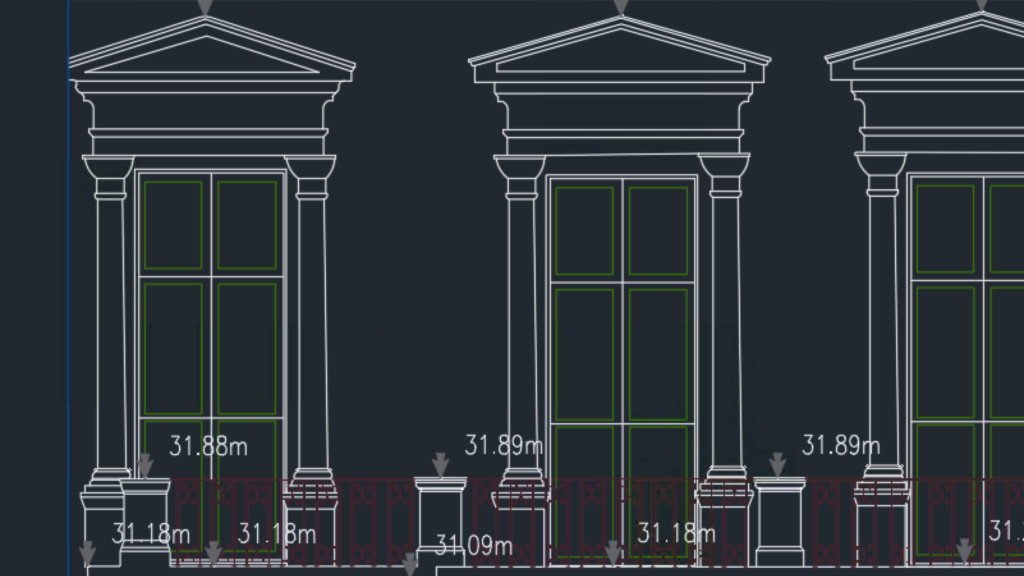
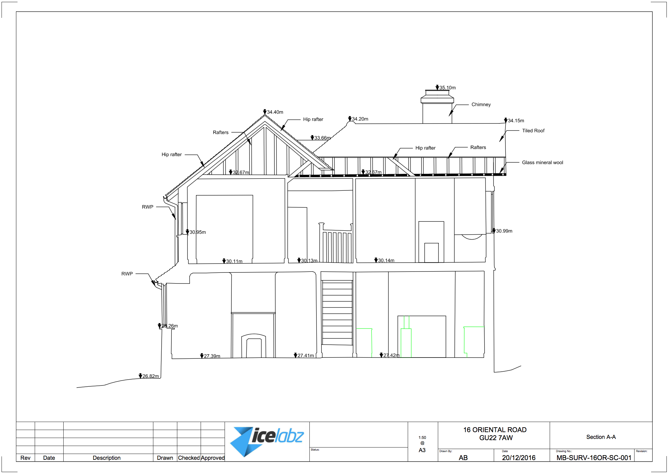
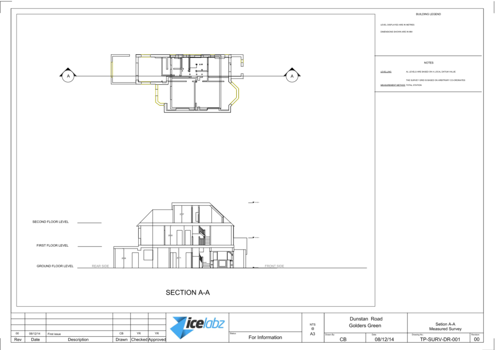
A section plan is a vertical slice drawings showing the internal features of your property. It is similar to an elevation plan. However, it shows the internal features of the property. It is common to have the section plan drawn in the middle of the property’s staircase. The section plan is to help the architect to get an idea of the height of the internal floors of the property and the features on the wall.
The section plan is usually combined with other plans on a measured building survey. This can include floor plans, elevations, topographical plans, roof plans. They are usually requested by your architect, and can also be produced from floor plans and elevations but it may take an architect or someone who has not visited the house a lot longer to produce.
Definition
A section plan is a 2D drawing of your house, showing it from all angles vertically. It’s a bird’s eye view of your home, from the side (well..through the house). It also shows the interior and exterior walls.
You can use section plans to communicate with builders or renovators so they can see what you want done in the right way. The plan is usually drawn on one sheet of paper but sometimes it will span two or three sheets if there are many rooms or views that need to be shown on it.
Some Examples
A section plan is a graphic representation of a building or object, usually in cross-section.
A section plan can be used to show the arrangement of different rooms, spaces and/or levels within an interior environment.
You can use a section plan for your own home or for any other building or vehicle you might want to see in details
Here are some examples of a section plan:
It is important to note (to avoid confusion):
The difference between an elevation and a section is that the elevation shows the external vertical plan of the building and the section shows the internal. It is quite common that we get enquiries asking for external sections, which does not exists… So if you are looking for external plan you’d need an elevation plan.
There are a few different ways to create a section plan. One common method is by hand, but it’s also possible to use software such as AutoCAD or SketchUp. To start, you’ll need to draw a 2D line drawing of your house.
You would want to start to draw up all your floor plans first so that you can get the layout and vertical dimensions (room height, door height and windows).
Once you’re done you have to draw your section line and which direction you need to draw.
then you would want to start aligning the floors against your section so that you can draw your internal of your house, then your height of each floor.
Then the hardest part is what you see from the section line. Check out the examples above to give you an idea of what features to pick
Then you can add labels and dimension lines on the house plans to indicate height, depth, and width as well as material types and construction details. Labels are useful for showing the location of rooms and other features on your building as well as giving an overview of any special structural elements that might be present in your home (such as trusses).
Interior design
How to read or draw a section plan.
A section plan is a drawing that shows the cross-section of a building. It can be drawn to show all of the floors, or it can show just one floor.
A section plan is different from an elevation, which shows an outside view of your house. A section plan shows how your house looks from inside or underneath it.
A section plan can give you good information about your house
A section plan is a drawing of a house in cross-section, which means it shows how the house is built from the inside down to its foundation. A section plan can show you:
The layout of each room in your house
How materials like wood, stone and metal are used within each room
How different parts of the house connect together (like walls with floors)
A floor plan is a drawing which indicate the features of a floor for your property. In the context of a measured building survey, a floor plan consists of indicating all fixed features, as well as height information of the room, windows, doors and any beams on the ceiling.
It differs greatly from your estate agent floor plan. The floor plan produced by your estate agent is not accurate enough for planning permission and construction drawings. They do not include room, window, door height or even show indications of beams. But they are good enough when you are trying to sell your property.
In addition the floor plans produced from a measured building survey is accurate as it measures the angle of the room. To undertake a proper measured building survey plan, you will need specialist equipment which ranges from £250-1000 a week to hire. This is why a measured building survey’s floor plan is slightly more expensive and take a lot longer to produce than the estate agent’s floor plan. To better explain what a floor plan is we have included a screenshot of a floor plan below:
The above floor plan uses an equipment called FARO 3D scanner, this is fairly expensive but very accurate. There are other equipments such as a total station that can be used to create the same output. But this can result in the survey taking a lot longer to complete (roughly 2-3 hours per floor). Whereas, the use of a FARO 3D scanner we can survey a floor in roughly 1 – 1.5 hours depending on the area and the number of rooms on that floor.