If you’d like to request a quote for an A Measured Survey, click the button below. Our team will work with you to determine the best approach for your specific needs and provide a customized solution. Please note that our team is available to discuss your requirements and provide a quote during standard business hours. We look forward to the opportunity to support your survey needs.
Tag: measured building survey
-

How Not to Throw Away £1000s on your next Measured Building Survey
- Refrain from revisiting the same location to avoid additional fees and maintain existing survey investment. Our quick response times enable us to respond to queries faster than competitors, providing a smoother and more efficient experience.
- Measured surveys can produce evergreen surveys that can be repeated for months after the initial survey, allowing clients to request additional sections or elevate the depth of the areas already surveyed. This flexibility enables us to continually assess and refine our understanding of clients’ needs, identify areas for improvement, and make data-driven decisions.
-

What is a provisional sum?
A provisional sum is a preliminary allocation of funds for a specific activity in a construction project that has not yet been fully defined. This provision is essential, as it allows for a rough estimate of costs, enabling clients to incorporate the sum into their budget. Construction projects often involve varying degrees of uncertainty, making a provisional sum a crucial component. According to a survey by the Royal Institution of Chartered surveyors, the use of provisional sums can be attributed to the uncertainty in project scope, client preferences, or planning process outcomes (Royal Institution of Chartered surveyors, 2020).
In the context of measured building surveys and topographical surveys, architects may request a provisional sum quotation to propose to their clients. This request acknowledges that the extent of the construction proposal is not always known, and a rough estimate is required to facilitate budget planning. In many cases, the client or architect is not entirely aware of the scope of the project, necessitating a ballpark figure to include in their budget. Insights from research by the Chartered Institute of Building, suggest that a significant proportion of construction projects involve the use of provisional sums due to complexity and uncertainty (Chartered Institute of Building, 2019).
The key characteristics of a provisional sum are that it is (1) an approximate figure, (2) allocated for an undefined or variable activity, and (3) not part of the scope for deliverables until instructed to proceed by the client. When a provisional sum is instructed, the architect or surveyor will confirm the scope and price (if any changes are made) and proceed accordingly. In this phase, the client is responsible for allocating funds to the itemised provisional sum (Royal Institution of Chartered surveyors, 2020).
It is essential to note that clients do not need to pay for provisional sums in the contract as they are not defined as deliverables. This aspect of provision sums should be clearly outlined in the quotation to prevent misunderstandings. A commonly cited concern is the practice of ‘fudging’ the provisional sum value, presenting it as part of a lump sum without intending to deliver the associated items (Chartered Institute of Building, 2019).
To avoid confusion, clients should ensure that provisional sums are itemized in the quotation, making it easier to identify the relevant amounts when applying for fees. It is also worth highlighting that contractors, surveyors, and designers will not need to deliver the provisional sum until instructed to proceed by the client. In any case, ensure accurate budget planning and scope definition to prevent unnecessary costs or lost opportunities. MCS, for instance highlights budget maintenance in project rollout as a good practice.
Provisional sums serve an essential purpose in the construction industry, providing a preliminary estimate and facilitating budget planning. While they require careful management to avoid misunderstandings, their utility cannot be overstated (Royal Institution of Chartered surveyors, 2020).
Remember to request itemized quotations and clearly outline the provisional sum provision and scope in your budget planning.
From here you can get a quote for a measured building survey from us by contacting us at info@icelabz.co.uk.
References
-

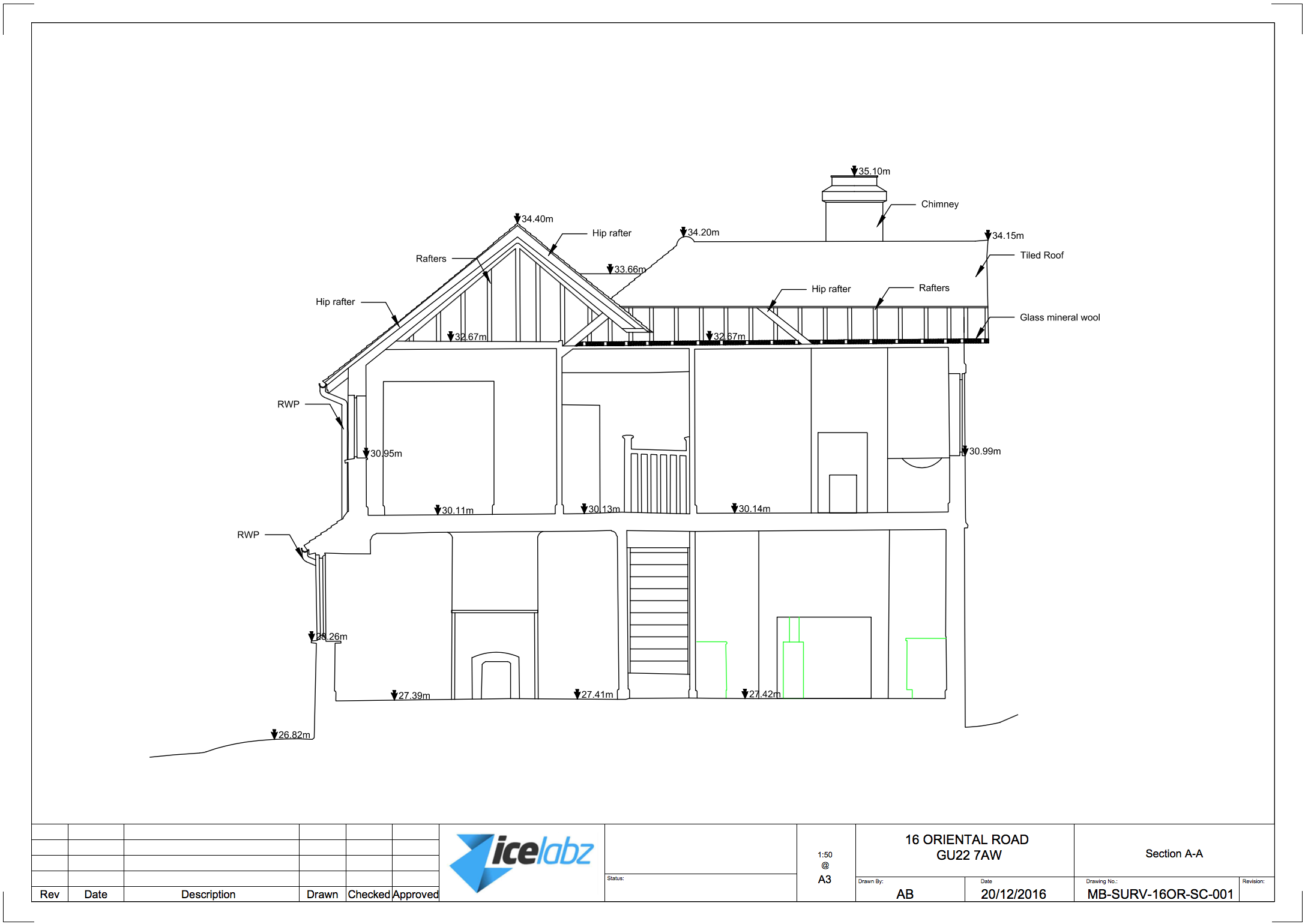
What is a Section Plan?
Definition
A section plan is a 2D drawing of your house, showing it from all angles vertically. It’s a bird’s eye view of your home, from the side (well..through the house). It also shows the interior and exterior walls.
Section plan is a type of drawing that shows the internal features of a property.
The section plan is usually combined with other plans on a measured building survey.
Section plans are used by architects to get an idea of the height of internal floors and features on the wall.
Section plans can be produced from floor plans and elevations, but it may take longer for someone who has not visited the house.
Section plans are usually drawn in the middle of the property’s staircase.
Section plans are used to communicate with builders or renovators to show what work needs to be done.
Some Examples
- A section plan is a graphic representation of a building or object, usually in cross-section.
- A section plan can be used to show the arrangement of different rooms, spaces and/or levels within an interior environment.
- You can use a section plan for your own home or for any other building or vehicle you might want to see in details
Here are some examples of a section plan:
It is important to note (to avoid confusion):
The difference between an elevation and a section is that the elevation shows the external vertical plan of the building and the section shows the internal.
Sample Section plan in PDF:
How to Draw a Section Plan
There are a few different ways to create a section plan. One common method is by hand, but it’s also possible to use software such as AutoCAD or SketchUp. To start, you’ll need to draw a 2D line drawing of your house.
- You would want to start to draw up all your floor plans first so that you can get the layout and vertical dimensions (room height, door height and windows).
- Once you’re done you have to draw your section line and which direction you need to draw.
- then you would want to start aligning the floors against your section so that you can draw your internal of your house, then your height of each floor.
- Then the hardest part is what you see from the section line. Check out the examples above to give you an idea of what features to pick
Then you can add labels and dimension lines on the house plans to indicate height, depth, and width as well as material types and construction details. Labels are useful for showing the location of rooms and other features on your building as well as giving an overview of any special structural elements that might be present in your home (such as trusses).

Interior design How to read or draw a section plan.
How to read or draw a section plan.
A section plan is a drawing that shows the cross-section of a building. It can be drawn to show all of the floors, or it can show just one floor.
A section plan is different from an elevation, which shows an outside view of your house. A section plan shows how your house looks from inside or underneath it.
Understanding Section Plans
A section plan is a valuable resource for understanding your house’s construction, offering insights into its internal layout and materials used.
A section plan provides a detailed drawing of a house in cross-section, showcasing how the house is built from the foundation to the roof.
- The layout of each room in your house
- Materials used within each room, such as wood, stone, and metal
- How different parts of the house connect together, like walls with floors
Still confused about section plans?
Take a look at an article on elevations for further understanding.
-

What is a floor plan?
A floor plan is a detailed drawing that provides a visual representation of the features on a specific floor of a property. In the context of a measured building survey, a floor plan includes all fixed features, such as room dimensions, windows, doors, and ceiling beams, as well as height information (Source: Authentic Property Survey). This type of floor plan is essential for planning permission and construction drawings, as it provides accurate measurements and layouts (Source: The RICS). The floor plan is a crucial component of a measured building survey, which involves measuring the property’s dimensions, layout, and features using specialized equipment (Source: Ratcliffe Property Surveyors).
Unlike estate agent floor plans, which are typically produced for marketing purposes and lack accuracy, measured building survey floor plans are designed to meet specific needs and requirements (Source: The National House-Building Council). These plans are created using specialized equipment, such as FARO 3D scanners or Leica Total Stations, which allow surveyors to capture precise measurements and layouts (Source: FARO Systems). As a result, measured building survey floor plans are more accurate and comprehensive than those produced by estate agents
Figurative 1: A screenshot of a floor plan produced from a measured building survey. This image shows the level of detail and accuracy that is achievable using specialized equipment and survey techniques. Note the precise measurements and layouts, as well as the inclusion of features such as windows, doors, and ceiling beams (Source: Authentic Property Survey). To better understand the potential cost and time implications of measured building surveys, consider the following:
Measured building surveys using specialist equipment can be more expensive, typically ranging from £250 to £1000 per week to hire (Source: Ratcliffe Property Surveyors). Additionally, these surveys can take longer to complete than estate agent floor plans, as the equipment and techniques used require more time and expertise. However, the resulting floor plans are more accurate and comprehensive, making them an indispensable tool for planning permission and construction drawings
To illustrate the level of accuracy and detail that can be achieved using measured building surveys, consider the use of equipment such as FARO 3D scanners. These scanners can capture precise measurements and layouts, and are capable of producing high-quality floor plans in a relatively short amount of time (Source: FARO Systems). Overall, measured building survey floor plans offer a level of accuracy and detail that is unmatched by estate agent floor plans, making them an essential component of planning permission and construction drawings
References